फायल:Map of Nicobar and Andaman Islands-en.svg

Size of this PNG preview of this SVG file: 263 × 598 चित्रतत्वां. हेर बारिकसाय: 105 × 240 चित्रतत्वां | 211 × 480 चित्रतत्वां | 337 × 768 चित्रतत्वां | 450 × 1,024 चित्रतत्वां | 900 × 2,048 चित्रतत्वां | 906 × 2,060 चित्रतत्वां।
मुळावी फायल (SVG फायल, नांवाक 906 × 2,060 चित्रतत्वां, फायलीचो आकार: 621 KB)
सारांश
| वर्णन | |
| तारीख | |
| स्रोत | स्वताचें काम. Self-made in Inkscape. Based on the 1976 CIA Indian Ocean Atlas (Andaman nicobar 76.jpg); bathymetry and topography from SRTM30_PLUS. |
| लेखक | Oona Räisänen (Mysid) |
| Other versions |
Derivative works of this file: |
| SVG genesis |
परवांगी
I, the copyright holder of this work, hereby publish it under the following licenses:
हाचे अंतर्गत ही फायल लायसेंस्ड आसा क्रिएटिव कॉमन्स एट्रीब्यूशन-शेयर एलाइक ३.० अनपोर्टेड़ लायसेंस ।
- तूं मेकळो आसा -
- वांटूंक – रचनेक कॉपी करूंक,वांटूंक आनी धाडूंक
- पुणर्मिश्रित करपाक – काम गरजेपरमणें अनुकुलीत करपाक
- सकयल दिल्ल्या अचींच्या अंर्तगत
- श्रेय – तुवें फावो तें श्रय दिवंक जाय, परवांगेक एक दुवो करुंक जाय, आनी कसलोय बदल केला जाल्यार दाखोवंक जाय. तुज्यान तें फावो ते परीं करुं येता, पूण ते परीं न्हय, ज्या वर्वीं दिसत की परवांगी दिवपी तुका वा तुंवे केल्ले उप्योगाक मान्यताय दिता म्हुण.
- अशेंच वांट – जर तूं ह्या रचनेन कसलेय बदल वा परिवर्तन करता वा हाचेर आदारीत कितेंय रचता जाल्यार तुवें तुज्या योगदानांक हेच लिसेंस, वा हाचें सारकेच लिसेंसाच्या अंतर्गत वांटूंक जाय.

|
हो दस्तावेज Free Software Foundation हाच्या पालवान प्रकाशीत जी॰एन॰यू फ़्री डॉक्यूमेंटेशन लायसेंस जाल्ली आवृत्ती 1.2 वा नवें (खंयचोच इन्वेरियेंट भाग, आनी फाटलें वा फुडलें आवरणाच्या मजकूरे बगर) हाच्या अंतर्गत कॉपी, वितरण वा बदल करपाची परवानगी दितात. ह्या लायसेंसाची एक प्रत जी॰एन॰यू फ़्री डॉक्यूमेंटेशन लायसेंस नांवाच्या भागांत आस्पावीत केल्या. |
तुमी तुमकां जाय तो परवानो वेंचून काडात
फायलीचो इतिहास
त्या वेळार फायल कशी आशिल्ली तें पळोवपाक त्या तारीख/वेळाचेर क्लिक करात
| दिस / वेळ | ल्हान-इमाज़ | परिमाण | वापरपी | शेरो | |
|---|---|---|---|---|---|
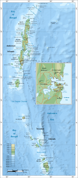
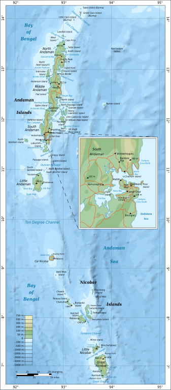
| आताचें | 21:54, 15 सप्टेंबर 2010 | | 906 × 2,060 (621 KB) | Mysid | {{Information |Description={{en|1=Map of the Nicobar and Andaman Islands.}} |Source={{own}}. Self-made in Inkscape. Based on the 1976 CIA Indian Ocean Atlas (File:Andaman nicobar 76.jpg); bathymetry and topography from SRTM30_PLUS. |Author=[[w:User:M |
फायलिचो वापर
हें पान ही फायल वापरता:
भुमंडळ फाइलीचो वापर
सकयल दिल्ल्यो विकी ही फायल वापरतात
- af.wikipedia.org चेर जाल्ले वापर
- ar.wikipedia.org चेर जाल्ले वापर
- ast.wikipedia.org चेर जाल्ले वापर
- az.wikipedia.org चेर जाल्ले वापर
- be.wikipedia.org चेर जाल्ले वापर
- br.wikipedia.org चेर जाल्ले वापर
- ca.wikipedia.org चेर जाल्ले वापर
- en.wikipedia.org चेर जाल्ले वापर
- eo.wikipedia.org चेर जाल्ले वापर
- es.wikipedia.org चेर जाल्ले वापर
- fi.wikipedia.org चेर जाल्ले वापर
- fi.wiktionary.org चेर जाल्ले वापर
- fr.wikipedia.org चेर जाल्ले वापर
- ga.wikipedia.org चेर जाल्ले वापर
- ha.wikipedia.org चेर जाल्ले वापर
- hi.wikipedia.org चेर जाल्ले वापर
- hi.wikibooks.org चेर जाल्ले वापर
- hy.wikipedia.org चेर जाल्ले वापर
- it.wikipedia.org चेर जाल्ले वापर
- ja.wikipedia.org चेर जाल्ले वापर
- mr.wikipedia.org चेर जाल्ले वापर
- oc.wikipedia.org चेर जाल्ले वापर
- pl.wikipedia.org चेर जाल्ले वापर
- pnb.wikipedia.org चेर जाल्ले वापर
- ru.wikipedia.org चेर जाल्ले वापर
- sw.wikipedia.org चेर जाल्ले वापर
- te.wikipedia.org चेर जाल्ले वापर
- tg.wikipedia.org चेर जाल्ले वापर
- uk.wikipedia.org चेर जाल्ले वापर
- ur.wikipedia.org चेर जाल्ले वापर
- www.wikidata.org चेर जाल्ले वापर
- zh.wikipedia.org चेर जाल्ले वापर