फायल:Saint Kitts and Nevis-CIA WFB Map.png
हाच्या परस वयले बारिक्साय उपल्बद ना
Saint_Kitts_and_Nevis-CIA_WFB_Map.png (326 × 350 चित्रतत्व, फायलीचो आकार: 6 KB, माइम प्रकार: image/png)
| वर्णन |
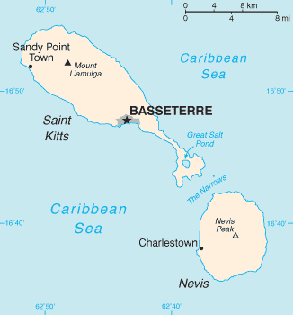
English: Map of the Saint Kitts and Nevis |
| स्रोत |
The World Factbook The Central Intelligence Agency, Langley, Virginia, USA |
| लेखक | Unknown author |
| Other versions | Image:Basseterre_Map_1.png |
This image is in the public domain because it contains materials that originally came from the United States Central Intelligence Agency's World Factbook.
|
 |
| date/time | username | edit summary |
|---|---|---|
| 01:08, 4. Nov 2004 | de:Benutzer:Zenogantner | |
| 23:47, 20. Okt 2003 | de:Benutzer:Head | (Karte Saint Kitts und Nevis, public domain aus dem CIA World Factbook: https://www.cia.gov/library/publications/the-world-factbook/geos/sc.html) |
Original upload log
Legende: (Aktuell) = dies ist das aktuelle Bild, (Löschen) = lösche diese alte Version, (Zurücksetzen) = verwende wieder diese alte Version.
- (Löschen) (Aktuell) 18:13, 1. Mär 2004 . . de:Benutzer:Raymond Raymond ( de:Benutzer_Diskussion:Raymond Diskussion) . . 330 x 355 (5252 Byte) (Karte ins Deutsche übersetzt)
- (Löschen) (Zurücksetzen) 23:47, 20. Okt 2003 . . de:Benutzer:Head Head ( de:Benutzer_Diskussion:Head Diskussion) . . 330 x 355 (6028 Byte) (Karte Saint Kitts und Nevis, public domain aus dem CIA World Factbook: https://www.cia.gov/library/publications/the-world-factbook/geos/sc.html archive copy at the Wayback Machine)
फायलीचो इतिहास
त्या वेळार फायल कशी आशिल्ली तें पळोवपाक त्या तारीख/वेळाचेर क्लिक करात
| दिस / वेळ | ल्हान-इमाज़ | परिमाण | वापरपी | शेरो | |
|---|---|---|---|---|---|
| आताचें | 18:42, 14 ऑगस्ट 2010 | | 326 × 350 (6 KB) | Ras67 | cropped |
| 07:48, 18 फेब्रुवारी 2006 |  | 327 × 352 (8 KB) | Hoshie | Updated map of Saint Kitts and Nevis from the CIA World Factbook, 10 Jan 06 rev: http://www.cia.gov/cia/publications/factbook/maps/sc-map.gif | |
| 14:47, 27 मार्च 2005 |  | 330 × 355 (6 KB) | Wolfman~commonswiki | {{CIA-map}} |
फायलिचो वापर
2 हीं पानां ही फायल वापरतात:
भुमंडळ फाइलीचो वापर
सकयल दिल्ल्यो विकी ही फायल वापरतात
- af.wikipedia.org चेर जाल्ले वापर
- als.wikipedia.org चेर जाल्ले वापर
- ar.wikipedia.org चेर जाल्ले वापर
- ay.wikipedia.org चेर जाल्ले वापर
- azb.wikipedia.org चेर जाल्ले वापर
- az.wikipedia.org चेर जाल्ले वापर
- be-tarask.wikipedia.org चेर जाल्ले वापर
- bg.wikipedia.org चेर जाल्ले वापर
- bn.wikipedia.org चेर जाल्ले वापर
- br.wikipedia.org चेर जाल्ले वापर
- ca.wikipedia.org चेर जाल्ले वापर
- da.wikipedia.org चेर जाल्ले वापर
- de.wikipedia.org चेर जाल्ले वापर
- de.wiktionary.org चेर जाल्ले वापर
- el.wikipedia.org चेर जाल्ले वापर
- en.wikipedia.org चेर जाल्ले वापर
- Saint Kitts and Nevis
- Sandy Point Town
- The Narrows (Saint Kitts and Nevis)
- User:Jannizz/SKN
- Great Salt Pond
- Pinney's Beach
- Outline of Saint Kitts and Nevis
- Index of Saint Kitts and Nevis–related articles
- Module:Location map/data/Saint Kitts and Nevis/doc
- Module:Location map/data/Saint Kitts and Nevis
- COVID-19 pandemic in Saint Kitts and Nevis
- en.wikisource.org चेर जाल्ले वापर
- eo.wikipedia.org चेर जाल्ले वापर
- es.wikipedia.org चेर जाल्ले वापर
- eu.wikipedia.org चेर जाल्ले वापर
- fa.wikipedia.org चेर जाल्ले वापर
- fi.wikipedia.org चेर जाल्ले वापर
- fr.wikipedia.org चेर जाल्ले वापर
- fy.wikipedia.org चेर जाल्ले वापर
ह्या फायलीचें वैश्वीक वापरांची चड म्हायती पळयात.