फायल:Anjediva isle map.jpg
हाच्या परस वयले बारिक्साय उपल्बद ना
Anjediva_isle_map.jpg (366 × 210 चित्रतत्व, फायलीचो आकार: 22 KB, माइम प्रकार: image/jpeg)
सारांश
| Description |
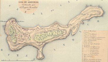
English: Map of the Isle of Anjediva (low resolution!) Português: Carta portuguesa da ilha de Anjediva (1885). |
|||||||||
| तारीख | ||||||||||
| स्रोत | http://www.supergoa.com/pt/fortes/f_anjediva.asp | |||||||||
| Creator | ||||||||||
| Geotemporal data | ||||||||||
| Bounding box |
|
|||||||||
| Georeferencing | ||||||||||
परवांगी
|
This work is in the public domain in its country of origin and other countries and areas where the copyright term is the author's life plus 100 years or fewer. | |
| This file has been identified as being free of known restrictions under copyright law, including all related and neighboring rights. | |
फायलीचो इतिहास
त्या वेळार फायल कशी आशिल्ली तें पळोवपाक त्या तारीख/वेळाचेर क्लिक करात
| दिस / वेळ | ल्हान-इमाज़ | परिमाण | वापरपी | शेरो | |
|---|---|---|---|---|---|
| आताचें | 17:29, 5 फेब्रुवारी 2009 | | 366 × 210 (22 KB) | Sanfy | {{Information |Description={{en|1=Map of the Isle of Anjediva}} |Source=http://www.supergoa.com/pt/fortes/f_anjediva.asp |Author=http://www.supergoa.com/ |Date=2009-02-05 |Permission= |other_versions=No }} <!--{{ImageUpload|full}}--> Category:Goa |
फायलिचो वापर
भुमंडळ फाइलीचो वापर
सकयल दिल्ल्यो विकी ही फायल वापरतात
- en.wikipedia.org चेर जाल्ले वापर
- es.wikipedia.org चेर जाल्ले वापर
- fr.wikipedia.org चेर जाल्ले वापर
- kn.wikipedia.org चेर जाल्ले वापर
- pt.wikipedia.org चेर जाल्ले वापर
- zh.wikipedia.org चेर जाल्ले वापर